


AirHUD Augmented Reality Drone Control Software
Enhanced Situational Awareness For Drone Pilots
AirHUD is the first real heads-up display for professional drone pilots, providing unlimited situational awareness.
View real-time information in a 3D 360° virtual space and see the drone in the sky at all times - even if it becomes obscured - to increase flight safety.
Obtain a detailed view of your flight path, potential obstacles, and other hazards that may be encountered during a mission, and overlay relevant data such as speed, altitude, and battery levels.
Create virtual boundaries or no-fly zones that issue alerts if the drone enters an area where it is not safe to fly.
AirHUD can benefit enterprise drone operations and can also be used as a training tool, enabling operators to practice in a simulated environment.
The AirHUD software is compatible with DJI drones and AR glasses, such as Microsoft HoloLens 2.
What Challenges Does AirHUD solve for drone operations?
Drone operations can have several problems, such as:
- Drone cannot be seen - too far away, is behind an obstacle, low-light conditions
- Poor situational awareness
- Legal requirement of a spotter
AirHUD changes this and tackles these problems. Key benefits include:
- Enhanced situational awareness on a totally new level, as the pilot sees it all and never loses the drone.
- Fly the drone behind obstacles and still see its location and relationship to surroundings intuitively.
- Height indicators are shown to allow for safe flights.
- Fly with confidence at night or during operations which exceed visual line of site, as the drone is always pinpointed in the air.
- Superimpose the display you would normally see on your controller over the real world, allowing you to see it and your aircraft simultaneously.
- Spotter person can be relieved to more productive duties.
- Helps keep the drone within visual line of sight, even when it is behind obstacles or obstructed.
- Fly confidently in low visibility conditions.
AirHUD Key Features
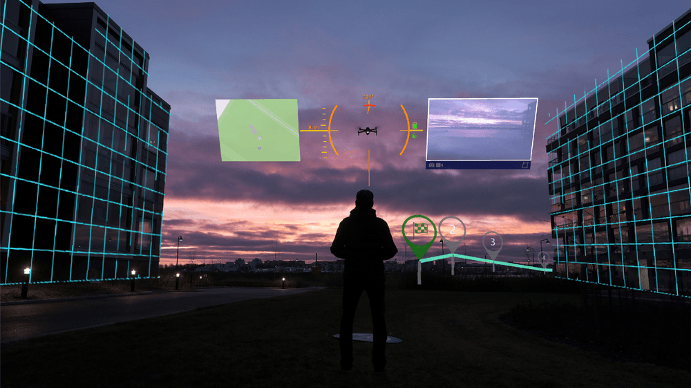
AirHUD Interface
AirHUD provides a wealth of data during a flight - all of which is easily accessible at any point of the mission.
This includes the drone’s status and location, real-time map, and waypoints, while airspaces and no-flight zones are clearly visible.
All of this data can be accessed via the AirHUD user interface - which features:
- Drone indicator, sky map, and cameras view
- Home position indicator and other world-based indicators
- Belt User Interface (Belt UI): Panels and map
Maps
Benefit from two types of maps - circular map and big map - which can be displayed during flight.
Key features include the ability to mark specific points on the map, upload waypoint missions, and zoom in/out to obtain more detailed views about the flight area.
- Circular Map (World Map): See where the drone, pilot, and home position are on the map.
- Big Map: Provides a better view of your flying area. See surrounding buildings and their heights as 3D elements on the map. Also, walk on the map to explore it in more detail.
Drone Indicators
See important information during the flight, including location information and aircraft performance indicators.
These elements include:
- Telemetry data, including latitude/longitude, altitude, distance from home position, and the drone’s compass heading.
- Drone indicator brackets show where the drone is.
- Important drone information, such as battery level, satellite reception, and remaining airtime.
- Access the live video feed from the drone’s camera(s).
- Sky Map enables you to see the map in the sky while flying.
Panels
The Belt UI consists of panels and a map to provide key information during flight.
Panels include:
- Diagnostics: provides you with a flow of information from the drone and / or controller. In case of a problem, or when you need to be informed, warnings are shown to you as notifications in this pane
- Telemetry: Detailed information about telemetry that flows from the connected drone, such as vehicle ID, heading, latitude/longitude, and altitude.
- Map: Access the live map.
- Connections: Access connection data between the AR glasses, the controller, the network and the drone. Icons are coloured-coded depending on whether the connections are successful or there are problems.
- Airspaces: See suitable areas and flight restrictions. All of these pieces of information are seen as 3D in the air.
AirHUD Training
AirHUD Training enables pilots to practice their flying skills in a simulated environment - and receive real-time feedback.
The immersive and lifelike experience enables operators to increase their confidence without the risk of crashing the drone or hitting obstacles.
Benefits include:
- Not weather dependant
- Fly a simulated drone in the classroom for basic controls training
- Fly a simulated drone outdoors in real environment to hone the skills
- Fly a real drone in real environment using AirHUD AR tools
- Simulate flights that follow CAA regulations
- Practice all the complex flying scenarios before you take your real test
Training can benefit enterprise operations, to better prepare teams to conduct real-world missions. Examples include:
- Search & Rescue/Public Safety: Train via realistic simulations of various rescue scenarios. Practice and refine skills in a safe, controlled environment to improve efficiency and effectiveness during actual missions.
- Industrial inspection: Fly a virtual drone to inspect a real piece of infrastructure, before flying an actual drone to collect data in a complex inspection scenario.
Drone Augmented Reality Use Cases
Transform enterprise drone operations with augmented reality.


